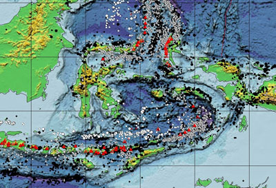
Scene from the online, interactive version of 'This Dynamic Planet.' The paper-version is the all-time best-selling map of the USGS.
Lab One: Asking Questions of Maps -
Interacting with the 'This Dynamic Planet' Map
|
|---|
Scene from the online, interactive version of 'This Dynamic Planet.' The paper-version is the all-time best-selling map of the USGS. |
The first version of the 'This Dynamic Planet' map was published in 1989 by the US Geological Survey, the Smithsonian Institution, and the US Naval Research Laboratory. The map exists in paper form with print on both sides (search for 'This Dynamic Planet'), in PDF form, and, starting back in 2006, an online, interactive, multi-layered thematic map. The online version, the version we are using for Lab One, supports additional information not shown on the printed version. All of the data layers (themes) in which you are exploring on the interactive map are stored on a remote web map server that waits for your requests and then returns your customized cartographic results. Similar interactive maps that support this type of query include those on the GES website.
In Lab One, you are exploring global geologic (tectonic, volcanic), geomorphic, physiographic, and ocean bathymetric information. You will discover that many of these themes are spatially related. You will capture two images that show a pattern you discovered while interacting with multiple data layers (themes). In Lab One, you must explain in a well written paragraph or two the pattern that you see, the possible relationship between the themes that you identified, and you will make a 'guess' or 'hypothesis' about the processes that you suspect caused (or formed) the pattern that you discovered. Also, you will answer the set of questions in red font below.
What do I mean by "a pattern that you discover?" Here's an example of a pattern that I found by using several themes on the map: I was scrolling around the map looking at the western US and noticed a curiously large, wide valley to the south-southwest of Yellowstone National Park (YNP). I noticed that YNP is a (massive) volcano formed by a stationary volcanic hot-spot. By also observing the direction of plate motion (the little arrows on the map) over the hot-spot, I realized that the large valley off to the south-southwest of the park (the Snake River Valley) was probably formed by earlier eruptions of the YNP volcano (previous large YNP 'supervolcano' eruptions literally blew away the mountains in the wake of the hot-spot as the plate passed over)!
Our Earth is a dynamic planet, as clearly illustrated on the main map by its topography, over 1,500 volcanoes, 44,000 earthquakes, and 170 impact craters. These features largely reflect the movements of Earth’s major tectonic plates and many smaller plates or fragments of plates (including microplates). Volcanic eruptions and earthquakes are awe-inspiring displays of the powerful forces of nature and can be extraordinarily destructive. On average, about 60 of Earth's 550 historically active volcanoes are in eruption each year. In 2004 alone, over 160 earthquakes were magnitude 6.0 or above, some of which caused casualties and substantial damage.
This map [This Dynamic Planet] shows many of the features that have shaped--and continue to change--our dynamic planet. Most new crust forms at ocean ridge crests, is carried slowly away by plate movement, and is ultimately recycled deep into the Earth--causing earthquakes and volcanism along the boundaries between moving tectonic plates. Oceans are continually opening (for example, Red Sea, Atlantic Ocean) or closing (for example, Mediterranean Sea). Because continental crust is thicker and less dense than thinner, younger oceanic crust, most does not sink deep enough to be recycled, and remains largely preserved on land. Consequently, most continental bedrock is far older than the oldest oceanic bedrock (see back of map).
The earthquakes and volcanoes that mark plate boundaries are clearly shown on this map, as are craters made by impacts of extraterrestrial objects that punctuate Earth's history, some causing catastrophic ecological changes. Over geologic time, continuing plate movements, together with relentless erosion and redeposition of material, mask or obliterate traces of earlier plate-tectonic or impact processes, making the older chapters of Earth's 4,500-million-year history increasingly difficult to read. The recent activity shown on this map provides only a present-day snapshot of Earth's long history, helping to illustrate how its present surface came to be.
The map is designed to show the most prominent features when viewed from a distance, and more detailed features upon closer inspection. The back of the map zooms in further, highlighting examples of fundamental features, while providing text, timelines, references, and other resources to enhance understanding of this dynamic planet. Both the front and back of this map illustrate the enormous recent growth in our knowledge of planet Earth. Yet, much remains unknown, particularly about the processes operating below the ever-shifting plates and the detailed geological history during all but the most recent stage of Earth's development.
A) Before you answer the questions in red font below, work through the following steps
B) Discovering Earth Patterns (your 'Pattern Discovery' Theme) on the 'This Dynamic Planet' Map