 |
 |
|
Figure 1 |
Figure 2 |
Figure 3 |
|
|
|
Figure 1 |
Figure 2 |
Figure 3 |
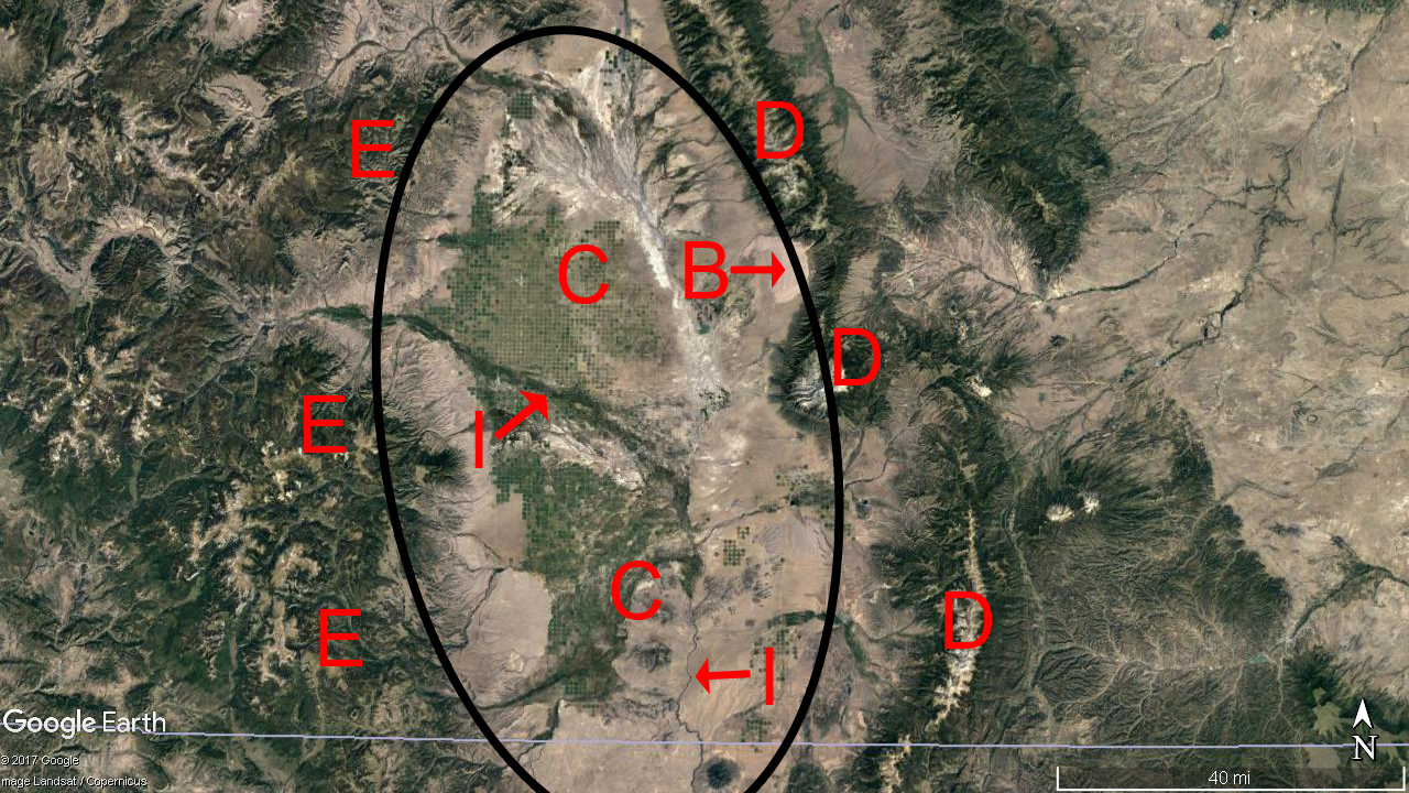
The San Luis Valley (SLV) is vast, high, and dry (circled in Fig. 1, 'C' in Fig. 2). The valley covers about 3,125 square miles, averages 7,700 ft. in elevation, and receives less than 10 in. of precipitation annually (Emery et al., 1969). Ninety-six percent of the SLV rests in Colorado, the remainder extends into North Central New Mexico. The valley’s flat landscape is bound to the east by gently grading alluvial fans and foothills (‘A’ in Fig. 2) and eastward and upward from there by the fault-block steep and serrated Sangre de Cristo Range (‘D’ in Fig. 1). The SLV is bound to the west by the rugged volcanic San Juan Mountains (‘E’ in Fig. 1). Both mountain ranges host peaks over 14,000 ft and were sculpted by a dozen or so glaciations, the last of which retreated about 15,000 years ago (Leonard et al. 2017).
In both ranges, glacially eroded ‘U’ shaped valleys now display sharply incised ‘V’ shaped notches in their bases, the result of 15,000 years of fluvial erosion. Along the eastern edge of the SLV, the transition from valley floor to high mountains is abrupt: The valley rises more than 6,000 ft. to the summit of Little Bear Peak - a distance of only five miles. From the San Juan Mountains, the iconic Rio Grande River emerges, flows through wetlands as it makes a gradual turn to the south, and passes just west of Taos, New Mexico through an eminent 500 ft. deep self-named gorge.
During the last ice age, the tallest sand dunes in North America (‘B’ in Fig. 1 and Fig. 2) formed in the SLV. Swollen streams and occasional glacial outburst floods filled the SLV with fine sediments for the wind to work. A prevailing southwesterly wind (i.e., from the southwest) blowing across these vast stream deposits forced air up and over the Sangre de Cristo Range. The wind was especially strong as it approached an eastward-pointing kink and associated wind gap in the Sangre de Cristo Range. This geological and climatological configuration supported sand deposition in a concentrated area on the windward side of this bend in the steep mountain front. With the retreat of the last ice age and drying conditions, the fresh supply of sand to this region was cut off. However, the sand deposit that remains is quite active and now goes by the name Great Sand Dunes National Park and Preserve.
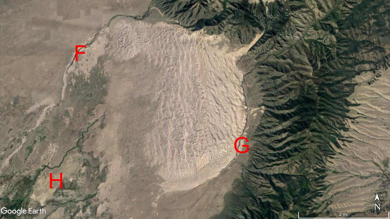
The park’s 40,000 acres of sand is literally trapped in a loop (Fig. 3). Across the dunes, sand grains bounce and jump and become entrained in the southwesterly wind. After traversing the dune field, the sand sloughs off in sheets, sometimes making a ‘booming’ sound (Nori et al., 1997), directly into Sand Creek (‘F’ in Fig. 3) and Medano Creek (‘G’ in Fig. 3). These two snowmelt-fed creeks circle the dune field as they run along its northwestern and southeastern halves. These wide but wadable creeks intercept and redirect all migrating sand. In these creeks, an eccentric flow pattern is observed. About every 15 seconds, an upstream-migrating wave passes (Schumm et al., 1982). During peak springtime flow, waves crest a foot high! Hugging the edge of the dunes, the two slowly sinking westbound creeks transport sand back to the windward side of the dune field (‘H’ in Fig. 3) where eventually the water disappears, the sand dries, and the southwesterly winds pick up.
This climatically-driven sand conveyor belt is occasionally broken by warm season weather events. The Sangre de Cristo range is notorious for initiating thunderstorms (Banta and Schaff, 1987). Nearby storms that fall apart with the loss of daytime heating send their cold, dense air plummeting Earthward. Any strong easterly outflow winds that blow across the dunes pause, or briefly reverse, the more typical eastward march of blowing sand. At Great Sand Dunes National Park and Preserve, this oscillating wind regime maintains the dunes’ height and keeps the dune crests looking sharp (Hands on the Land, 2017). Cloud-to-sand lightning strikes weld sand clasts together forming dendritic tubular glass structures called fulgurites. Samples of these rarities are on display at the National Park’s visitors center.
These volcanic, tectonic, glacial, aeolian, climatic, meteorological, and fluvial processes connect to the modern day SLV through a dry atmosphere and soil, a short three to four month growing season, extreme wind, heat, and cold, and a high-contrast beauty. Those who live in the SLV enjoy a dark nighttime sky and animated textures that emerge at sunrise and sunset in the form of a mountain-lined horizon and a corrugating sky.
References
Banta, R., and Schaaf, C. 1987. Thunderstorm genesis zones in the Colorado Rocky Mountains as determined by traceback of geosynchronous satellite images. Monthly Weather Review, 115(2): 463-476.
Emery P., Boettcher A., Snipes R., and McIntyre, H. 1969. Hydrology of the San Luis Valley, South-Central Colorado. U.S.D.I., US Geological Survey, Open File Report, June.
Hands on the Land / NPS. 2017. Reversing Dunes. https://www.handsontheland.org/grsa/resources/reversing.htm. Last accessed 26 December 2017.
Leonard, E., Laabs, B., Schweinsberg, A., Russell, C., Briner, J., and Young, N. 2017. Deglaciation of the Colorado Rocky Mountains following the Last Glacial Maximum. Cuadernos de Investigación Geográfica, 43.
Nori, F., Sholtz, P., and Bretz, M. 1997. Booming sand. Scientific American, 277(3).
Schumm, S., Bean, D., and Harvey, M. 1982. Bed-form-dependent pulsating flow in Medano Creek, Southern Colorado. Earth Surface Processes and Landforms, (7):17-28.
Brandon Vogt, January, 2018